The History of Adams Boulevard Crenshaw to Fairfax .


- Details
- Category: Community News
- Published on Saturday, 16 December 2017 14:55
- Written by Dianne Lawrence
 Some TNN readers living westerly of the West Adams District, in the neighborhoods west of Crenshaw south of the freeway and north of the Expo Line railroad tracks to Culver City, citing sources such as Wikipedia and the LA Times, argued that they too are a part of the West Adams District.
The authors, Laura Meyers and Mitzi March Mogul, responded by digging into the actual history of these areas, all of which were a part of the original Rancho Las Cienegas. They uncovered a really interesting history of these neighborhoods:
“Los Angeles’ tremendous growth in all directions has necessitated thorough-going improvements in many localities which a few years ago were considered rural districts. It is in the memory of most Angelenos, when West Adams from Rimpau out to the junction of Adams and Washington, was nothing more nor less than a part of the country which one went through on the way to the beach.”
When these words appeared in the Los Angeles Times in March of 1926, most readers likely nodded their heads in agreement. After all, the area being referred to – the lands (more than 3,000 acres) that comprised the remaining portions of the Rancho Las Cienegas – had only in the past decade or so been annexed into the City of Los Angeles. Before World War I, the “Cienega District,” as it was often called, was mostly home to ranches, farms and even the Sentous packinghouse, a 20-acre slaughterhouse operation with its own train stop just past where Adams and Washington met.
But somehow the community names that were so familiar to readers in 1926 – “Cienega” and “Bonita Meadows” chief among them – have been lost to residents (and L.A.’s local media) today, leading to a new discussion about “what’s in a name” for today’s neighborhoods lying west of Crenshaw and south of the freeway to the Culver City border.
In 1910, the Cienega District, as it was commonly called, lay beyond the farthest western boundary of Los Angeles, and also was west of the West Adams District. A large portion of the land was controlled by Caroline Hauser, the family of Francisca Abila de Rimpau, James Whitworth, and the A.J.D. Keating estate, which owned the 340-acre Bonita Meadows Ranch and nearly 1,000 more acres from Cienega to Santa Monica and today’s Marina del Rey. Although several train lines from Los Angeles built-up tracts southwest of downtown took visitors to the ocean, it was not until 1913 that Adams Street was paved past Montclair Avenue (just east of today’s Crenshaw Boulevard) - although motorists were occasionally seen coursing along its dusty, rutted path.
Sure, there were a few housing subdivisions here and there in this swath of countryside. DuRay Place was one. “Do you realize,” one 1912 ad proclaimed, “that the present magnificent Wilshire and West Adams districts were raw farm land a few years ago? DU RAY PLACE adjoins the West Adams section right in the line of greatest development….[Du Ray Place is] absolutely the greatest real estate investment opportunity for the man of modest means in or around Los Angeles.”
Glen Airy Place was another – advertised in 1912 as “The Tract of the Hour, near the fashionable West Adams District” west of Crenshaw Boulevams from 23rd to 28th Avenues (approximately Vineyard to Longwood) was announced in 1912 with “views of the Cienega Hills.” West View Heights was laid out north of that, nearer to Washington Boulevard (separated now by the freeway). An investors magazine noted that Adams Street, now traveling past the Du Ray Place tract (just west of today’s Cochran Avenue), “Is steadily pushing beachward” – even though, then as now, it came to a dead halt where it met Washington Boulevard.
However, with America entering WWI and wartime’s economic downturns, these tracts didn’t really take off until the late 'teens and early twenties. Today one sees a few small pre-war Craftsman style homes but these neighborhoods are predominantly developed with such popular 1920s styles as Spanish, Tudor and Classic Revival bungalows.
A Little More History
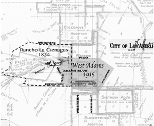
In 1834, Los Angeles’ original pueblo grant was extended to 16 square leagues, "two leagues in the direction of each of the four winds." Not very precise, but it was understood that its border on the west went to the ranchos La Brea and Las Cienegas, the latter owned by the Abila family.
Francisco Avila (also written “Abila”) had arrived in the pueblo by 1794, and became alcade (mayor) in 1810. Thirteen years later, the new Mexican government granted him the Rancho Las Cienegas, 4,439 acres lying seven miles west of the pueblo in the marshlands more or less east of today’s La Cienega Boulevard between Wilshire Boulevard and Jefferson/Exposition. In 1858, Theodore Rimpau, who had married Francisca Abila, and his family moved to the ranch.
By 1871, the rancho was partitioned in the U.S. courts. Januario Abila ended up with almost 900 acres (one-fifth of the Rancho Las Cienegas), with his sister, Francisca Abila de Rimpau, also receiving 900 acres. Henry Gird also received a one-fifth share at the southwest corner of the rancho, where he operated a dairy that by 1889 had been renamed Bonita Meadows. The remaining two-fifths of the ranch were divided among ten more people. By the beginning of the 20th century, many of the easternmost parcels, especially those up on the mesas, were being developed into swanky tracts in the West Adams District, with both mansions and middle-class homes lining the streets during its heyday.
But the lowlands remained rural, cattle herds still running free on vast swaths of land.
The designation “West Adams District” had grown to have a great deal of cachet, so in the City’s relentless move west new subdividers often promoted their elegant tracts as being a part of it. These enclaves sat up on the mesas, often with views east to downtown, north to the hills, and southwest/west to the ocean. The flat rancho lands below and southwest sat on the former river bed of the former course of the Los Angeles River, which once joined the Ballona Creek on the way to the Pacific Ocean.
Everything began to change when the City brought in water from the Owens Valley, and escalated when the Keating estate holdings were finally broken apart and sold.
The establishment of the Los Angeles Aqueduct initially provided the city with fourfold the amount of water it actually needed. City officials, noting they were saddled with a large municipal bond, made water a “powerful lure” to entice neighboring communities to join Los Angeles. In 1915 an odd-shaped, gerrymandered swath of land known as the “Palms Addition” was added to the city territory, adding 7.3 square miles but skip jumping over some of the former Rancho Las Cienegas while including other tracts. Historian and observer J.M. Guinn wrote, “The new city boundary was zigzagged and criss-crossed to take in the advocates and leave out the opponents. In some [school] districts the school-house was in the annexed district and the pupils outside, and vice versa in others. The western city boundary line in the annexed district resembles the teeth of a Brobdingnagian saw.”
But this was ultimately resolved. A few years earlier, in 1911, the million-dollar estate of nitrite-and-gold magnate Andrew J. D. Keating was finally resolved, after years of legal wrangling among the heirs (after Keating’s death in a shipwreck in 1901, his elderly widow Isabel married a 36-year-old paramour, and then died just months into her honeymoon of cirrhosis of the liver; her new husband, Issac H. Smith, became her successor heir, much to the chagrin of the children).
Some of Bonita Meadows was transferred to a developer, Carlin Geer Smith (no relation to Issac), who not only built up Du Ray Place – named for his father – but then married one of the Keating daughters, Helena. Beginning soon after the Palms Addition, Carlin Smith began to lobby Los Angeles officials, asking them to annex the area of his subdivisions – which he now called the “West Adams Extension District.” But the city’s elected officials turned down the application, and Smith bitterly complained that “the people of that district will be deprived of the advantage of city gas rates, electric rates and city drainage.”
Meanwhile, the Cienega School District was established, along with a Cienega municipal electric lighting district. School officials announced the construction of the Cienega Elementary School (still located on Adams between Orange and Sycamore). Its groundbreaking was in 1917, and the school had opened by the early 1920s when the nearby community was primarily Jewish, according to Cienega Elementary’s published history.
Smith did finally get his way, with another hopscotch annexation in the southwest corner of the former Bonita Meadows (between Adams and Exposition) added to Los Angeles in 1918. Cienega was annexed in 1923, and the smaller Rimpau Addition (by now surrounded by the City of Los Angeles) was finalized in 1924.
The City of Los Angeles was now complete to Culver City’s borders.
So, how did these important place names – Cienega, Bonita Meadows, Rimpau, Glen Airy Place, Du Ray Place – become lost to history? Should they be revived to describe one of today’s most popular communities?
The answer is beyond the scope of this historical review. But perhaps we have given residents some tools to begin anew the task of creating an identity and a sense of place for themselves.

News Category
-
Community News
In The CD 10 Race, Only One Candidate Has Earned The Right To Lead The District
 reprinted from CityWatch LA October 07 2024ELECTION 2024 - When you know the story of how Heather...
-
Neighborhood Councils
NEIGHBORHOOD COUNCIL UPDATE
Local Neighborhood Councils are a proactive way to become involved in your relationship with the...
-
City News
Communities Preparing for Disaster
 by Bob Gelfand CitywatchLAGELFAND’S WORLD - In a week of sometimes depressing news, I would like...
-
Crime Reports
HOW TO TELL IF YOU ARE THE TARGET OF A PHONE SCAM
 Every year, thousands of people lose money to telephone scams — from a few dollars to their life...
-
Local Development
WHAT IS DESTINATION: PICO AND WHY IS IT DOING ALL THOSE NICE THINGS ON PICO?
 Destination: Pico is a community nonprofit working to make Pico Boulevard more walkable, vibrant,...
Today2
Yesterday16
Week18
Month334
All990887
Kubik-Rubik Joomla! Extensions
Yesterday16
Week18
Month334
All990887
Currently are 17 guests and no members online
Kubik-Rubik Joomla! Extensions